A strategic analysis of integrated geophysical innovation and its commercial implications
Preamble: The Problem With Looking Underground
Every infrastructure project, mining operation, and archaeological survey faces the same constraint: we’re remarkably blind to what lies beneath our feet. Current subsurface investigation methods ground-penetrating radar, seismic surveys, core drilling deliver isolated snapshots. They’re expensive, time-consuming, and critically, they don’t talk to each other.
The cost is staggering. Urban sinkholes cause billions in damage annually. Mining companies drill thousands of exploratory boreholes, most yielding marginal data. Archaeological sites are destroyed before discovery. Critical infrastructure water mains, foundations, tunnels fails without warning because we lack continuous monitoring.
Enter MESOM: A Systems-Level Solution
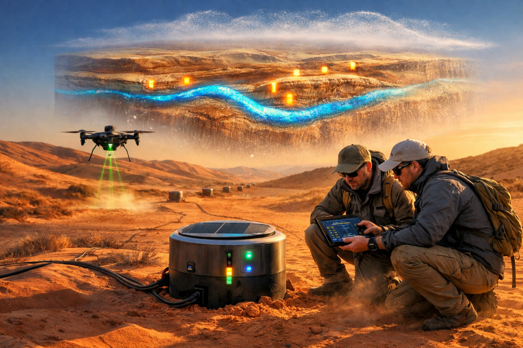
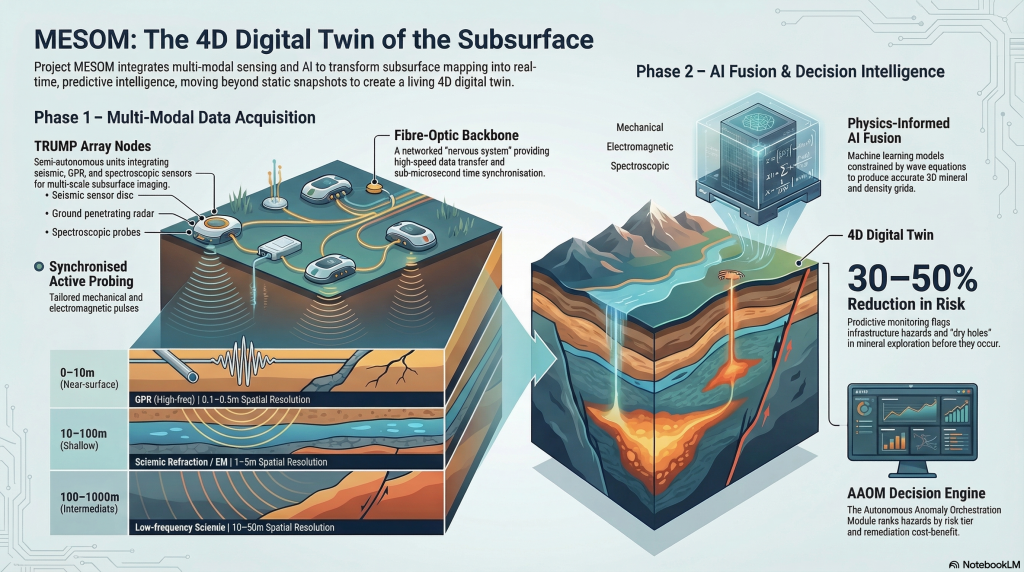
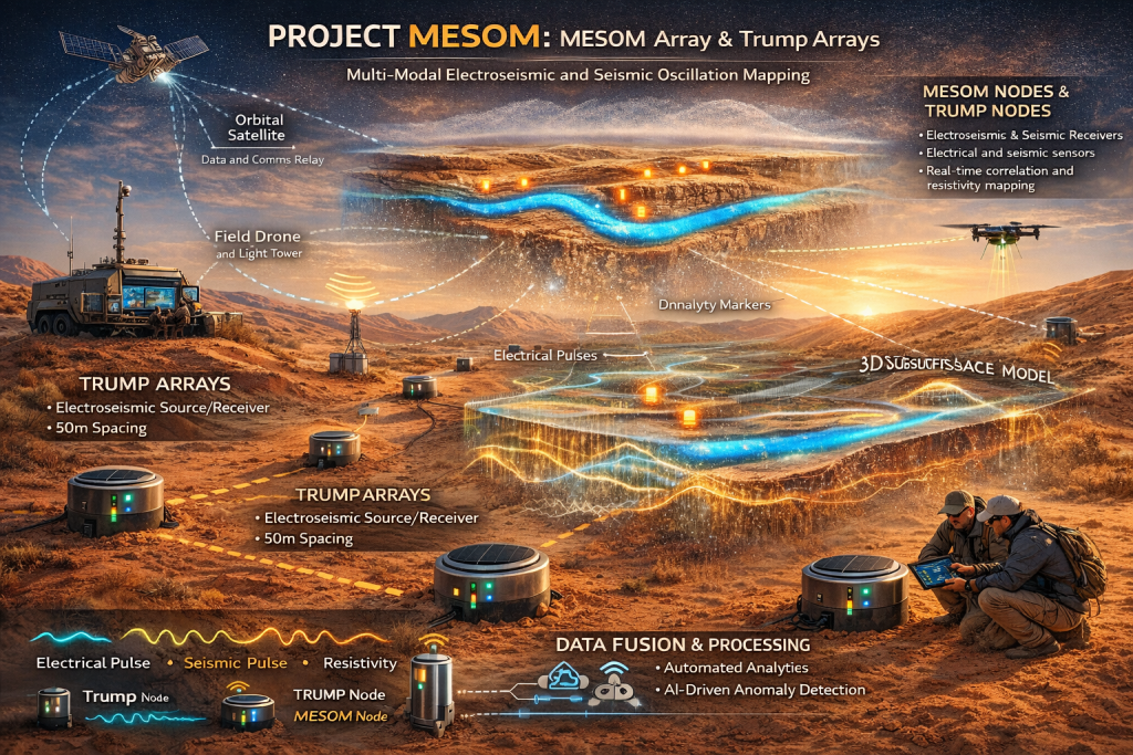
Project MESOM (Multi-modal Electroseismic and Seismic Oscillation Mapping) proposes something audacious: a living digital twin of the subsurface. Not another sensor. Not incremental improvement. A fundamental reimagining of how we understand what’s underground.
The innovation centers on “Trump Arrays” yes, that’s the actual technical term (Transmissive Resonant Units for Multimodal Probing). These semi-autonomous nodes deploy across landscapes like a nervous system, each containing:
- Resonant inducers that generate synchronized mechanical and electromagnetic pulses
- Multi-spectral sensors capturing seismic, radar, and spectroscopic data
- Edge AI processors filtering signals in real-time
- Mesh networking creating coordinated observation networks
The breakthrough isn’t hardware it’s orchestration. A single Trump node activates. Signals propagate through rock, soil, and voids. Dozens of neighboring nodes capture the complex interference patterns. AI fuses mechanical wave data with electromagnetic responses, surface spectroscopy with deep seismic returns.
As usual some analysis artifacts : MESOM artifacts
Here is a concise table with the document name and a short, plain-English description of each attached file.
| Document name | Short description |
| Project MESOM: Multi-Modal Electroseismic and Seismic Oscillation Mapping. Comprehensive Framework Document | Defines the overall MESOM concept, including the sensing philosophy, Trump Array architecture, AI-driven data fusion, deployment models, and cross-domain use cases for subsurface intelligence. |
| Project MESOM: Business Requirements Document (BRD) | Specifies the business goals, internal stakeholder needs, governance model, KPIs, and service orchestration requirements needed to deploy and operate MESOM as an enterprise-grade platform. |
| Project MESOM: Transmissive Resonant Units (TRUs) Hardware Requirements Document | Details the technical specifications, performance targets, environmental constraints, power systems, and vendor criteria for the physical sensor nodes used in MESOM deployments. |
| Technical Integration Framework for Multi-Modal Subsurface Intelligence (MESOM) | Provides the end-to-end technical architecture showing how sensors, data ingestion, AI fusion, decision layers, and external systems integrate into a scalable, standards-compliant MESOM platform. |
| MESOM Data Integration Taxonomy | Comprehensive Classification of Data Types, Sources, Services, and Outputs |
Why This Matters Now: The Business Case
Three macro-trends make MESOM commercially viable today:
1. Infrastructure Crisis Meets Predictive Maintenance
The UK alone has £1+ trillion in aging infrastructure. MESOM transforms reactive failure response into predictive monitoring. Permanent arrays detect subsidence, void formation, and structural degradation months before catastrophic failure. The ROI is immediate: prevented failures pay for decades of monitoring.
2. Resource Efficiency Under Capital Constraints
Mining and exploration companies face brutal economics commodity price volatility, rising capital costs, regulatory pressure. MESOM cuts exploratory drilling costs 40-60% by mapping viable deposits with unprecedented precision before a single drill turns. In resource extraction, information advantage is margin.
3. Carbon and ESG Compliance Becomes Quantifiable
Monitoring carbon sequestration sites, tracking groundwater contamination, verifying mine closure these aren’t nice-to-haves anymore. They’re regulatory requirements with financial teeth. MESOM provides auditable, continuous verification that traditional surveys can’t match.
The Technology Stack: Mature Parts, Novel Integration
MESOM succeeds precisely because it doesn’t depend on moonshots:
- Seismic technology: 100+ years mature, oil industry-proven
- GPR systems: Commercial off-the-shelf, archaeologist’s standard tool
- Spectroscopy: Lab-quality instrumentation now field-deployable
- AI fusion: Physics-informed neural networks, Bayesian inference—research-grade but productizable
- DATA : Historical Collection, Integration Smoothing, and Timeline Mapping: Refer to the MESOM Data Integration Taxonomy in MESOM artifacts . see appendices for the additional requirement for data coordination and integration and the ability to have a historical timeline view to review changes based on past data from various sources.
- Elevate temporal intelligence from implicit feature to explicit architecture. Every MESOM component Trump Arrays, AAOM, data standards needs temporal specifications. This isn’t scope creep; it’s structural completion. Without it, MESOM is a sophisticated spatial snapshot system. With it, MESOM becomes the temporal-spatial nervous system for subsurface intelligence.
The leap is systems integration the same leap that made smartphones revolutionary. Every component existed before 2007. Apple’s genius was assembly and orchestration. MESOM is the iPhone moment for subsurface intelligence.
Strategic Deployment Models
Permanent Observatory Networks
Target: National geological surveys, critical infrastructure operators
- Grid deployments: 100+ nodes, years-long operation
- Continuous monitoring of seismic risk zones, water resources, carbon storage
- Revenue model: SaaS subscription + data products
- Reference: Seismic monitoring networks already operate globally; MESOM adds 10x information density
Mobile Campaign Services
Target: Mining exploration, archaeology, construction projects
- Rapid deployment: days to weeks, 20-100 nodes
- Dense mapping before commitment of capital
- Revenue model: Per-km² surveying fees, comparable to traditional geophysical contractors but faster and richer data
- Competitive advantage: Multi-modal fusion delivers better anomaly detection than single-method competitors
Urban Resilience Networks
Target: Municipal governments, utilities, insurance
- Targeted arrays over aging infrastructure corridors
- Early warning for sinkholes, tunnel degradation, foundation settlement
- Revenue model: Risk-reduction contracts, public-private partnerships
- Justification: Single prevented catastrophic failure pays for city-wide network
The Investment Landscape: Where Capital Meets Geology
Technical Risk: LOW All core technologies are proven. Integration requires engineering, not research breakthroughs. Pilot deployments can validate within 12-18 months.
Market Risk: MODERATE Adoption requires education geophysicists, civil engineers, mining geologists must embrace multi-modal thinking. Early pilots with tier-1 partners (mining majors, national surveys) create demonstration effects.
Regulatory Risk: LOW TO MODERATE Existing frameworks cover seismic monitoring and geophysical surveys. Data governance and liability need contractual clarity but no new regulations required.
Competitive Moat: SIGNIFICANT Network effects compound—more nodes generate richer datasets, better AI models, stronger predictions. First movers who build pilot networks and train domain-specific AI create multi-year advantages.
Critical Success Factors
Interdisciplinary Integration Success depends on geophysicists, AI engineers, and domain experts speaking the same language. Pilot teams must be genuinely cross-functional, not siloed specialists.
Data Governance & Standards MESOM’s value multiplies if datasets interoperate. Early adoption of open standards (OGC SensorThings API, STAC metadata) creates ecosystem advantages.
Uncertainty Quantification Every output must carry confidence intervals. Decision-makers need to know not just “anomaly detected” but “91% confidence, actionable at £50k intervention threshold.” This is what makes AI defensible in regulated industries.
Phased Capital Deployment Start with constrained pilots—single sites, limited duration. Validate economics before scaling. Mining exploration offers fastest ROI validation (months, not years).
Timeline to Commercial Viability
Q1-Q2 2026: Pilot funding (£300-500k), first urban void detection campaign Q3-Q4 2026: Archaeological site validation; publish reference architecture 2027: First commercial deployments; 5-10 operational sites 2028-2030: Scale to 50-100 sites; establish MESOM as subsurface intelligence standard
The Bigger Picture: Digital Twins Go Underground
MESOM represents the fourth domain of digital twin deployment:
- Manufacturing: Jet engines, wind turbines (mature)
- Buildings: HVAC, structural health (emerging)
- Cities: Traffic, energy grids (pilot phase)
- Subsurface: Geology, hydrology, infrastructure (MESOM opportunity)
Just as manufacturing digital twins justified themselves through predictive maintenance ROI, subsurface twins will justify through catastrophic failure prevention and capital efficiency in exploration.
What Strategists Should Watch
- Pilot announcements: Which mining companies, national surveys, or municipalities go first?
- AI model sharing: Does MESOM become a platform with federated learning, or do operators keep models proprietary?
- Quantum integration: When do quantum gravimeters and magnetometers reach field-deployment price points?
- Insurance products: Do carriers create “geophysical error” policies that accelerate adoption?
Final Thought: Seeing Farther Underground Than We See In Space
We have higher-resolution maps of Mars than of the ground beneath London, Lagos, or Los Angeles. MESOM doesn’t just fill that gap it creates continuous, updatable understanding.
For societies dependent on aging infrastructure, for industries extracting finite resources, for cities vulnerable to subsidence and flooding, subsurface intelligence isn’t a luxury. It’s survival infrastructure for the 21st century.
The question isn’t whether integrated subsurface monitoring becomes standard. It’s who builds it first and captures the data network effects.
Appendices: Other considerations:
What’s Missing: Temporal Intelligence Architecture
The documents describe spatial gaps (coordination, standards, uncertainty) but underspecify the temporal dimension. Here’s what’s absent and why it matters:
1. Temporal Data Lineage & Provenance Tracking
What’s Missing:
- No systematic framework for tracking when data was captured, under what conditions, and how reliability degrades over time
- Legacy data (Victorian tunnel surveys, 1960s seismic lines, medieval mine maps) exists but lacks temporal metadata standards
- Current MESOM framework doesn’t specify how to weight a 2025 DAS measurement vs. a 1987 borehole log vs. a 1780 hand-drawn catacomb map
Why It’s Necessary (Not Additional):
- Calibration drift: A seismic survey from 1995 used different frequency ranges and processing than 2025 methods. Without temporal calibration functions, you’re comparing apples to oranges
- Geological change: Groundwater tables shift, voids propagate, foundations settle. A “living digital twin” that treats all historical data as equally current is fundamentally flawed
- Legal liability: If MESOM recommends intervention based partly on 1940s mining records, and those records prove unreliable, who’s liable? Temporal provenance creates audit trails
Integration Path:
Every data point needs temporal metadata:
– Acquisition timestamp
– Instrument calibration date
– Processing method version
– Environmental conditions at capture
– Confidence decay function (accuracy degrades over time)
AI fusion weights data by:
– Recency (exponential decay for dynamic features like water tables)
– Permanence (low decay for bedrock structure, high for fluid content)
– Cross-validation (when 2020 GPR confirms 1890 tunnel map, boost both)
2. Stratigraphic Time Integration: Deep Time vs. Human Time
What’s Missing: The MESOM framework mentions carbon dating and chronometry but doesn’t architect how geological timescales (millions of years) integrate with infrastructure timescales (decades) and monitoring timescales (minutes).
Gap Analysis:
- Geology operates on Ma (million-year) scales: “This sandstone formed 280 Ma ago”
- Archaeology operates on ka (thousand-year) scales: “This tomb dates to 3200 BP”
- Infrastructure operates on decade scales: “This water main installed 1972”
- Monitoring operates on real-time: “Deformation detected 14:37 UTC today”
Current systems treat these as separate domains. MESOM promises integration but doesn’t specify the temporal reconciliation engine.
Why It’s Necessary:
- Predictive modeling requires rates: You can’t predict void propagation without knowing formation age, stress history, and current loading
- Failure forensics: When a sinkhole opens, investigation traces backwards through decades (construction), centuries (previous subsidence), millennia (karst formation). Without temporal integration, you’re blind to causality
- Heritage vs. hazard prioritization: A Roman aqueduct collapse has archaeological value (preserve) and safety risk (stabilize). Decision logic depends on accurately dating the structure and modeling its degradation trajectory
Integration Architecture:
Multi-Scale Temporal Fusion:
LAYER 1: Geological Baseline (Static)
– Rock formations (10⁶-10⁹ year timescales)
– Tectonic history
– Paleo-environment reconstruction
→ Provides boundary conditions, doesn’t update frequently
LAYER 2: Archaeological/Historical Context (Quasi-Static)
– Carbon-dated artifacts (10²-10⁴ year accuracy)
– Historical construction records (documents, maps)
– Previous survey campaigns (decades to centuries old)
→ Updates when new excavations or archives discovered
LAYER 3: Infrastructure State (Slow Dynamic)
– As-built drawings (decade-scale)
– Maintenance records (annual)
– Previous failures (event-based)
→ Updates quarterly or after interventions
LAYER 4: Environmental Monitoring (Fast Dynamic)
– Groundwater levels (seasonal, monthly)
– Seismic activity (continuous)
– Temperature, precipitation (hourly)
→ Updates in real-time
LAYER 5: Active Sensing (Real-Time)
– Trump Array measurements (on-demand or continuous)
– DAS fiber-optic vibration (streaming)
– Automated anomaly detection (millisecond latency)
→ Continuous feedback loop
3. Historical Change Detection: What Moved, When, and Why?
What’s Missing: No explicit 4D differencing engine that compares:
- 1950 aerial photography
- 1985 geological survey maps
- 2003 GPR campaign
- 2015 LiDAR scan
- 2025 Trump Array deployment
Current State: These exist as isolated datasets. Humans manually overlay and eyeball differences.
MESOM Opportunity: Automated temporal registration and change attribution.
Why It’s Necessary:
- Validation of models: If your 2025 model predicts void location that matches a 1960 subsidence event you didn’t train on, confidence skyrockets
- Acceleration detection: Gradual settlement (1mm/year for 50 years) vs. accelerating settlement (1mm/year → 5mm/year over last 3 years) implies different failure modes
- Climate impact quantification: Rising water tables, permafrost thaw, coastal erosion—all require multi-decade temporal baselines
Integration Design:
# Pseudo-architecture for temporal intelligence
class TemporalDataPoint:
value: float
location: (x, y, z)
timestamp: datetime
acquisition_method: str
uncertainty: float
decay_function: callable # how confidence degrades over time
class TemporalFusionEngine:
def weight_by_age(data_point, query_time):
age = query_time – data_point.timestamp
if data_point.is_permanent_feature: # bedrock depth
decay = 0.01 # barely degrades
elif data_point.is_seasonal: # water table
decay = function_of_season(age)
elif data_point.is_structural: # building foundation
decay = fatigue_model(age, loading_history)
return data_point.uncertainty * (1 + decay * age)
def detect_temporal_anomalies(historical_series):
“””Flag when current measurements deviate from historical trend”””
baseline = fit_trend(historical_series[:-recent])
recent_data = historical_series[-recent:]
if recent_data outside prediction_interval(baseline):
alert(“Acceleration detected”, confidence, rate_of_change)
4. Predictive Horizons: How Far Forward Can You See?
What’s Missing: MESOM discusses real-time monitoring and “living digital twins” but doesn’t specify forecast horizons or temporal uncertainty propagation.
Critical Questions Unanswered:
- Can MESOM predict sinkhole formation 6 months in advance? 6 weeks? 6 days?
- How does prediction confidence decay with time horizon?
- What’s the “half-life” of a subsurface model before it needs re-calibration?
Why It’s Necessary:
- Intervention planning: If you can reliably predict failure 6 months out, you plan proactive repair. If only 6 days, you plan evacuation
- Insurance pricing: Actuarial models require temporal risk curves, not just “high/medium/low”
- Capital allocation: Mining companies need multi-year deposit models. Municipalities need decade-scale infrastructure planning
Integration Addition:
Temporal Prediction Framework:
SHORT-TERM (hours to days):
– Trigger: Real-time Trump Array + weather data
– Use case: Flash flood undermining, construction vibration damage
– Confidence: High (physics-based, recent calibration)
MEDIUM-TERM (weeks to months):
– Trigger: Trend analysis + seasonal models
– Use case: Groundwater-driven subsidence, freeze-thaw cycles
– Confidence: Moderate (depends on weather forecast accuracy)
LONG-TERM (years to decades):
– Trigger: Geological models + climate projections + infrastructure aging
– Use case: Strategic infrastructure planning, heritage preservation
– Confidence: Low to moderate (model uncertainty compounds)
Each prediction includes:
– Forecast timestamp
– Confidence interval (widens with time horizon)
– Key assumptions (if X changes, forecast invalid)
– Update trigger (recalibrate when new data arrives)
Is Historical Timeline Capability Additional or Necessary?
ANSWER: Structurally Necessary
Here’s why it’s not optional:
1. Legal Defense Requires Temporal Audit Trails When MESOM-informed decisions go wrong (and some will), liability defense depends on proving:
- “We used the best available data at the time“
- “We appropriately weighted historical vs. current observations”
- “We documented when models were last calibrated”
Without temporal provenance, you have no legal leg to stand on.
2. Physics-Informed AI Fails Without Temporal Context Rock doesn’t teleport. Voids propagate. Foundations settle gradually (usually). Physics-informed neural networks need temporal constraints:
- Continuity: State at time T+1 must be physically reachable from state at time T
- Conservation: Mass/energy balance over time
- Causality: Causes precede effects
If your AI fusion ignores temporal ordering, it will “learn” that effects cause their causes. Garbage models.
3. Active Learning Can’t Prioritize Without Temporal Value-of-Information MESOM’s “active learning” recommends which samples to analyze next. Optimal selection depends on:
- Information decay: Dating a 50-year-old artifact has more calibration value than a 5-year-old one (less temporal uncertainty)
- Temporal coverage gaps: If you have no data between 1920-1980, samples from that era are more valuable
- Change detection: Samples from periods of known environmental shifts (drought, flooding) validate change models
Without temporal intelligence, active learning degrades to random sampling.
4. The Business Case Depends on Temporal ROI Investors ask: “How long before this system pays for itself?”
The answer depends on:
- Failure prediction lead time: 6-month warning = time for proactive repair (cheap). 6-day warning = emergency evacuation (expensive)
- Model longevity: If models need monthly recalibration, operational costs are high. If annual, manageable
- Historical data leverage: If MESOM can extract value from decades of legacy surveys (rather than requiring fresh data), deployment costs drop 40-60%
All of these are temporal value calculations.
Integration Roadmap: Adding Temporal Intelligence to MESOM
Phase 1: Temporal Metadata Standards (Q1-Q2 2026)
- Define schema: Every data point gets timestamp, acquisition method, uncertainty, decay function
- Retrofit legacy data: Digitize historical maps with “best guess” temporal metadata
- Tool development: Auto-tagging pipelines for ingesting old surveys
Phase 2: Multi-Scale Temporal Fusion (Q3-Q4 2026)
- Build 5-layer temporal architecture (geological → real-time)
- Implement temporal weighting algorithms (how to combine 1960 borehole + 2025 Trump Array)
- Validation: Show that temporal fusion improves accuracy vs. “latest data only”
Phase 3: Change Detection & Prediction (2027)
- Automated 4D differencing: Compare any two epochs, flag significant changes
- Temporal anomaly detection: “This deformation rate is accelerating beyond historical norms”
- Forecast horizons: Produce short/medium/long-term predictions with explicit confidence decay
Phase 4: Temporal Digital Twin (2028+)
- Full 4D visualization: Scrub backwards/forwards through time
- “What-if” temporal scenarios: “If we drain this reservoir in 2029, what’s the subsidence prediction for 2035?”
- Causal modeling: Distinguish correlation from causation across decades
Final Assessment: Temporal Intelligence is the Missing Infrastructure Layer
The current MESOM framework is spatially sophisticated but temporally naive. It treats time as a logging parameter rather than a first-class dimension of intelligence.
What Gets Unlocked When You Fix This:
Operational:
- Reliable failure prediction with quantified lead times
- Automated validation against historical records (model confidence boost)
- Intelligent prioritization of expensive lab work (active learning with temporal value-of-information)
Strategic:
- Defensible liability frameworks (temporal audit trails)
- Accurate ROI calculations (temporal benefit curves)
- Long-term infrastructure planning (decade-scale confidence intervals)
Scientific:
- Causal inference (not just correlation across time)
- Climate impact quantification (multi-decade baselines)
- Heritage preservation (linking deep geological time to human cultural time)
Recommendation:
Elevate temporal intelligence from implicit feature to explicit architecture. Every MESOM component—Trump Arrays, AAOM, data standards—needs temporal specifications. This isn’t scope creep; it’s structural completion.
Without it, MESOM is a sophisticated spatial snapshot system. With it, MESOM becomes the temporal-spatial nervous system for subsurface intelligence.
subsurface intelligence, geophysics, underground mapping, digital twins, infrastructure resilience, predictive maintenance, AI in engineering, seismic sensing, ground penetrating radar, spectroscopy, sensor fusion, smart infrastructure, urban resilience, mining technology, archaeological technology, climate risk monitoring, ESG analytics, systems engineering, deep tech innovation, data integration, decision intelligence,

