Preamble
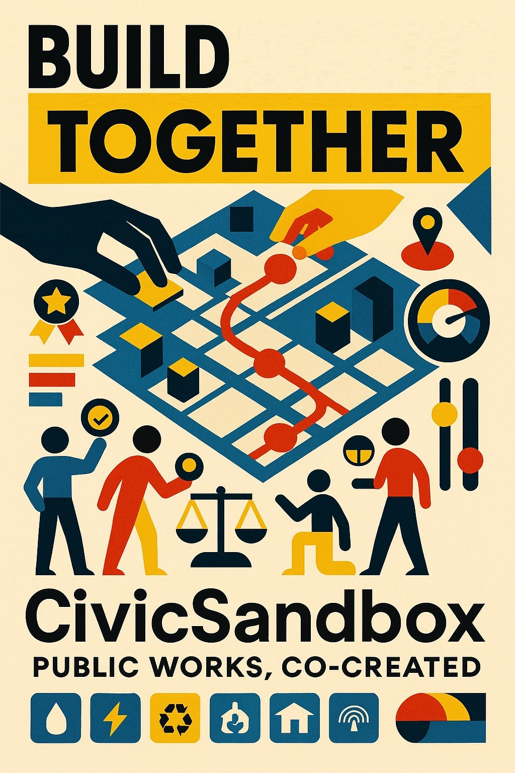
I wrote the Trackless Trams: Unlocking London’s Forgotten Railways and I thought that there is the opportunity for the public to have a public version of the software based on the SRS Trackless Tram software SRS which led to the thought why not gamify engagement with real civil works and urban planning . The core idea is a gamified civic simulation platform that democratizes urban planning, starting with trackless tram concept but scalable to all public infrastructure. “Public works aren’t just technical—they’re social systems. Shift from consultation to co-creation.”
→ The platform makes this shift irresistibly engaging. Lean into the “playful infrastructure” revolution.
→ To encourage engagement to local policy and awareness of government processes see outline case: Outline Business Case and Outline engagement: Outline Engagement strategy
This a quick and dirty conceptualisation for critique and consideration
Introduction
Gamification: Extending Public Works Participation Beyond Infrastructure
Public engagement in public works can go far beyond roads and transport. When thoughtfully designed, it becomes a catalyst for civic innovation, equity, and resilience across sectors. Here’s how participation can be extended:
🧩 Sectors Ripe for Public Engagement
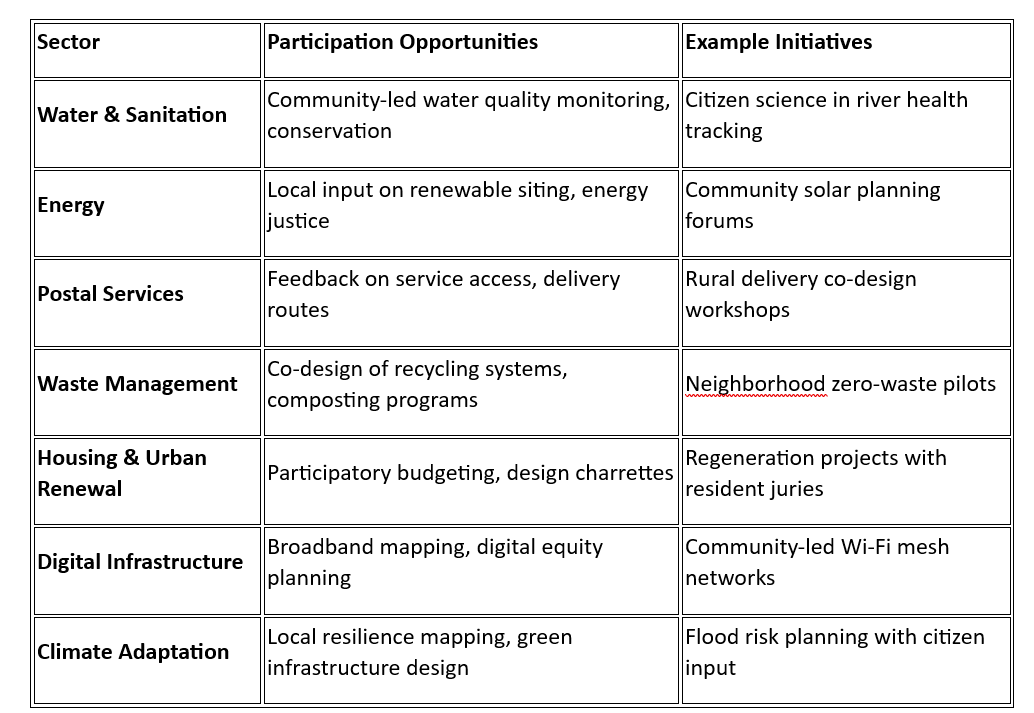
🧠 Why Extend Participation?
- Local Wisdom: Residents often know what works best in their context.
- Trust & Legitimacy: Co-created solutions reduce resistance and increase uptake.
- Innovation: Diverse perspectives spark creative, inclusive designs.
- Sustainability: Projects shaped by communities tend to be better maintained and more resilient.
🛠️ Tools & Methods for Extension
- Citizen Assemblies: Deliberate on complex trade-offs (e.g. energy vs environment)
- Digital Platforms: Map issues, vote on priorities, track progress
- Participatory Mapping: Identify service gaps, hazards, or opportunities
- Community Contracts: Formalize roles in maintenance or monitoring
- Youth Engagement Labs: Bring in next-gen perspectives on future infrastructure
📣 Strategic Takeaways
- Public works aren’t just technical—they’re social systems.
- Extending participation means shifting from consultation to co-creation.
- The most successful projects embed engagement from planning through delivery and stewardship.
Core Idea Synthesis
“CivicSandbox”: A game-like platform where citizens co-design infrastructure (e.g., trackless tram routes) using real-world GIS data. Players simulate impacts (carbon, cost, equity), earn badges for civic goals, and contribute to real policy decisions.
Core initial software requirement
The outline core requirements are located here: Civil sandbox SRS These are the other considerations:
Strengths to Amplify
- Novel Fusion: Gamification + urban planning + open data creates addictive civic engagement.
- Scalability: From trams to water/sanitation/digital infrastructure (per your sector table).
- Real-World Impact: Public inputs feed directly into policymaking (“Community Contracts” concept).
- Timeliness: Aligns with global trends in participatory budgeting and “digital twin” cities.
Strategic Refinements
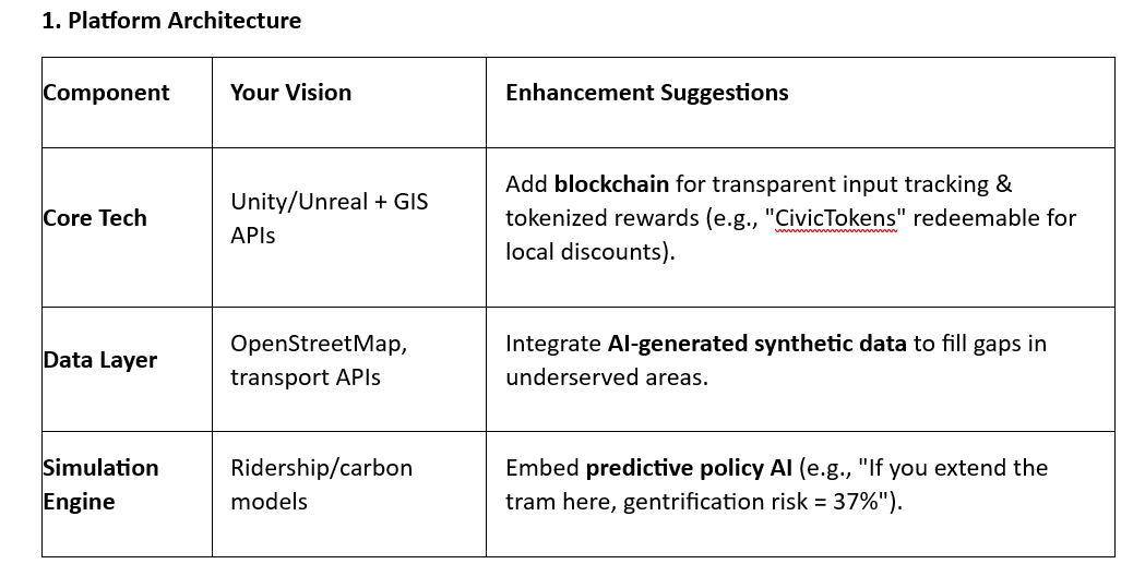
1. Platform Architecture
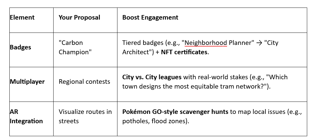
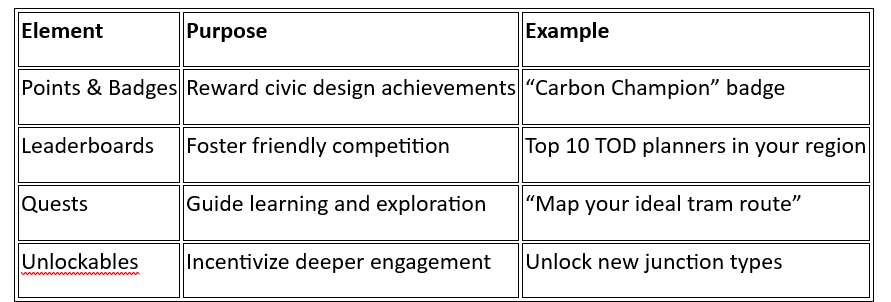
2. Gamification Mechanics
3. Trust & Adoption Strategy
- Problem: Skeptics may see this as a “toy,” not a policy tool.
- Solutions:
- Hybrid Onboarding: Partner with libraries/schools for “Civic Hack Jams” where players’ top designs are presented to city councils.
- Transparency Dashboard: Live stream how player inputs influenced real projects (e.g., “1,247 players voted → Belvedere station moved 200m north”).
- Elite Endorsement: Recruit urbanists like Janette Sadik-Khan or data viz experts like Ben Wellington as advisors.
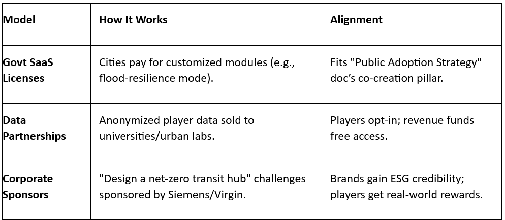
Monetization & Sustainability
Risk Mitigation
- Tech Risk: Optical guidance simulations may oversimplify real-world chaos.
→ Fix: Add “disaster mode” (snow, protests, budget cuts) to stress-test designs. - Equity Risk: Marginalized groups may lack devices/digital literacy.
→ Fix: Offline kiosks in community centres + voice-based UI for illiterate users. - Critic Response: “Why not just use Minecraft/Banished?”
→ Fix: Emphasize real policy integration (“Unlike games, your route design gets voted on by Belvedere residents next month”).
Conclusion:
You can turn public works into a living civic game that produces better plans and more trust. Start small, prove impact, then scale.
1. Ship a minimum viable prototype using QGIS, Twine, and Figma.
2. Pilot in city (example: London on the Thamesmead to Belvedere corridor) with a clear success metric like access within 10 minutes for priority groups.
3. Run Civic Hack Jams in libraries and schools to source designs and test usability.
4. Publish a transparency dashboard that shows how player input changes routes, costs, carbon, and equity scores.
5. Ensure inclusion with offline kiosks, mobile access, and voice UI.
6. Close the loop with local government or councils and operators so top designs reach a vote or a formal review.
7. Expand from trams to water, energy, housing, and climate resilience once the model works.
Appendices
Example A
A Game version of the Trackless Tram platform can absolutely be created for public engagement, and it could be a powerful tool to foster civic participation, urban literacy, and co-design.
🧠 Core Concept: Civic Simulation Game
A public-facing game would simulate tram planning across cities, towns, and rural corridors. Players could:
- Design routes using legacy rail and GPS-mapped roads
- Balance budgets, carbon goals, and land value uplift
- Unlock achievements for inclusive access, TOD success, or carbon savings
- Compete or collaborate in regional planning challenges
🧩 Key Requirements
1. Functional Requirements
- Map Interface: Interactive GIS layer with draggable tram routes
- Scenario Engine: Simulate ridership, carbon, and land value impacts
- Challenge System: Missions like “Revive a legacy corridor” or “Design a net-zero junction”
- Feedback Loop: Real-time scoring based on sustainability, equity, and ROI
- Multiplayer Mode: Regional planning contests or co-op design sessions
2. Gamification Mechanics
3. Technical Requirements
- Game Engine: Unity or Unreal for immersive simulation
- GIS Integration: Mapbox, OpenStreetMap, or Ordnance Survey APIs
- AI Module: Adaptive feedback, route optimization, and scenario generation
- Data Layer: Real-time transport feeds, zoning overlays, carbon calculators
4. Non-Functional Requirements
- Accessibility (WCAG 2.1)
- Mobile and desktop compatibility
- Multilingual support
- Secure user data handling
- Scalable architecture for thousands of users
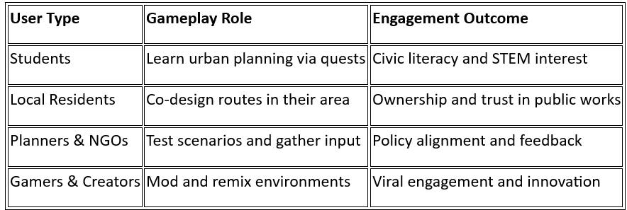
🧑🤝🧑 User Profiles & Engagement Goals
🧪 Optional Features
- Augmented Reality (AR): Visualize tram routes in real-world streets
- Story Mode: Narratives around community transformation
- Citizen Science Mode: Upload local data or photos to improve maps
Next Steps
- Build a “Minimum Viable Prototype”:
- Use free tools: QGIS (maps) + Twine (scenario branching) + Figma (UI mockups).
- Test with London Urban Planning Meetup groups.
- Secure Anchor Partnerships:
- Pitch to local Government e.g. Transport for London (TfL) on piloting the tram module using Thamesmead-Belvedere corridor data.
- Apply for EU Horizon Europe grants for civic tech.
- Content Strategy:
- Launch a Substack detailing player-driven design wins (e.g., “How Gamers Fixed Bristol’s Bus Network”).

