Preamble
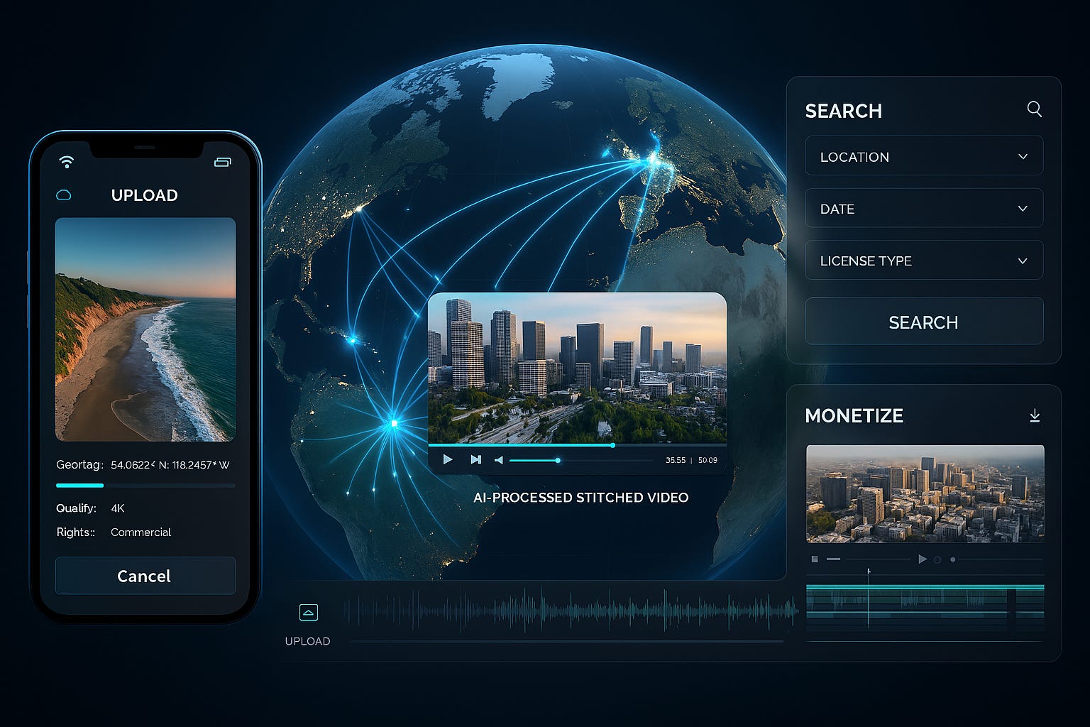
Open Aerial brings drone pilots, editors, agencies, and civic users into one pipeline. Contributors upload geo tagged footage with releases. AI scores quality, aligns and stabilizes shots, colour matches sequences, and stitches multi contributor reels. Buyers search by map and time, then license clips with clear payouts to every contributor by seconds used. This connects contribution to monetization with transparent rights and audit trails.
Vision Statement
The platform aims to create the largest, and most valuable library of geo-tagged drone footage by enabling anyone to contribute, aggregate, and monetize aerial content. Leveraging AI, the platform seamlessly stitches together drone footage from multiple contributors, making high-quality aerial media readily searchable, licensable, and usable by various stakeholders.
As usual outline: SRS Business case and other artifacts: Open Aerial artifacts note some documents are labelled as SkyShare AI (as the name is TBD) and are initial docs
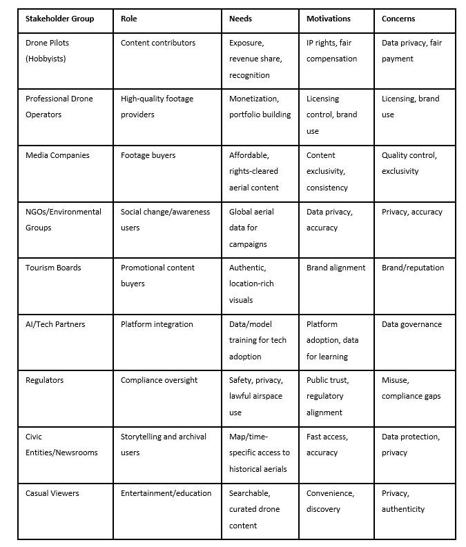
Stakeholder Identification and Analysis
Pain Points
· Fragmented Solutions: Current drone platforms either specialize in sharing, editing, or mapping—but not all three. Contributors lose value due to absence of a centralized, rights-managed platform.
· Lost Value: Thousands of hours of drone footage remain unused as there is no effective aggregation, rights management, or monetization system.[
· High Entry Barrier: AI stitching and professional editing are costly for individuals; a collaborative compilation process would reduce costs.
· Slow Post-Production: Editors spend substantial time on stabilizing and matching footage, while buyers seek verified, instantly licensable aerials sorted by geo/time.
· Unclear Rights and Payouts: Rights management is complex, with unclear contributor incentives and monetization routes.
· Regulatory Pressure: Compliance with evolving drone regulations, such as Remote ID requirements and airspace mapping, is increasingly essential.
Solution Features
· Contributor App: Upload capability with auto-captured metadata, batch tagging, releases, and payout setup.
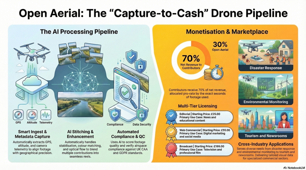
· AI Ingest and Stitching Pipeline: Handles ingest, duplicate checks, scoring, alignment, stabilization, color matching, and seamless composition of reels and clips.
· Map and Timeline Search: Geo-temporal search interface for both contributors and buyers, with instant licensing and delivery.
· Rights and Monetization Dashboard: Rights-setting templates, transparent revenue share (typically 70% to contributors by seconds used), payout records, and takedown/dispute workflows
· Quality Control: AI and manual checks for GPS sanity, focus, shake, horizon, noise profile, and compliance with airspace/privacy requirements.
· Admin and Moderation Tools: Rights audit, fraud detection, compliance tracking, automated geofencing, and takedown SLAs.
· Bounty Challenges and Collaboration Spaces: Allow buyers to request footage for specific events, locations, or timeframes, and enable contributors to compete or collaborate
· APIs for Enterprise Partners: Programmatic archive querying, usage-based licensing, and vertical integration with third-party apps, editing platforms, and mapping stacks
Product & Service Description: See appendices for further details
The platform operates as a media pipeline from upload to payout, integrating community contribution, advanced AI stitching, licensing, and transparent revenue management:
· Contributors: Upload geo-tagged footage, auto-extract metadata, tag in batches, set rights, and receive transparent payouts.[2][3]
· Buyers and users: Search by map, date/time, and scenario; instantly license stitched sequences or atomized clips (editorial, commercial, broadcast, enterprise tiers). Teirs: free, paid and subscription model tbd
· Revenue Model: 30% platform take, 70% contributor split by seconds used; tiered licensing and subscriptions for both pro contributors and buyers; enterprise APIs for bulk access and delivery.
· Compliance Model: Automated checks for no-fly zones, regulatory and privacy compliance, metadata validation, GDPR adherence, and dynamic geofencing.
Novel Uses & Applications
· Disaster Response: Rapid aggregation and dissemination of aerial footage for crisis mapping, relief coordination, and time-anchored change detection.
· Environmental Monitoring: Longitudinal tracking of ecosystem changes, forest regeneration, coastal erosion, and climate analytics.
· Historical City Timelines: Building visual archives for cities, showcasing evolution, public works, and storytelling applications.
· Tourism & Promotional Content: Branded location-rich visuals, allowing tourism boards and cities to showcase authentic aerial perspectives.
· Education & Public Engagement: Tools for schools, drone clubs, and civic groups to contribute and consume structured aerial media, building spatial literacy.
· Media & Entertainment: Thematic compilations and streaming-ready montages, leveraging AI for storytelling and narrative content creation.
· NGO & Social Change: NGOs, newsrooms, and foundations using aerial media for campaigns, fundraising, and impact measurement.
Further Novel ideas
- Attribution graph for payouts. Track exact frames from each contributor inside every stitched output, then split the 70 to 30 marketplace revenue by seconds used. This rewards precision and collaboration.
- Map plus timeline search. A buyer drags across a map and scrubs a time slider to see stitched flyovers for that place and date range, not just single clips.
- Bounties with compliance guardrails. Buyers post requests for a location and window. Contributors see live airspace rules and privacy prompts before flying.
- Premiere and Resolve plugins. Editors preview the stitched reel, then pull only the seconds they need with rights embedded in the export.
- City timelines. Continuous community captures show change over months. Ideal for news, planning, and education.
Gamification
Purpose, grow high quality, rights clean supply while teaching good capture habits. Mechanics:
• Skill tiers. Cadet, Pilot, Ace. Each tier unlocks higher bounty limits and better revenue multipliers tied to quality scores, metadata completeness, and on time deliveries.
• Weekly ingest challenges. Themes like coastal erosion, sunrise skylines, or bridges. Winner selection blends quality score, watch time, and buyer saves.
• Streaks and flight badges. Consecutive compliant uploads with full releases earn badges that surface in buyer search.
• Team flights. Small squads tackle bounty lists, then share payouts by contribution seconds.
Sharing telemetry
Why, safer flying, better stitching, and trusted provenance. What to share on opt in: GPS traces, altitude, yaw, pitch, roll, capture start time, device model, frame rate, resolution, and lens FOV. The platform validates GPS sanity, detects duplicates, and improves alignment. Sensitive data like faces and plates is blurred before delivery. Store telemetry with lifecycle controls and show a clear DPIA in product docs for large scale processing.
Access levels:
• Private, contributor only for training and QC.
• Platform, used for stitching, fraud checks, and rights audits.
• Buyer visible, limited proof of provenance and capture window when a license is active.
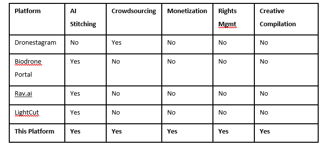
Competitive Differentiation
Risks and Mitigation
· IP Disputes: Blockchain-based rights tracking, clear contributor agreements, automated takedowns.
· Quality Assurance: Pre-filters, tutorials, feedback loops, and minimum scoring for footage acceptance.
· Regulatory Compliance: Geo-fencing, permission checks, airspace/Remote ID mapping, privacy zone tools.
· Cold Start: Anchor clients, bounty programs, and phased pilots with disaster response and tourism boards.
· Compute Costs: Tiered processing models, archive storage, and scalable backend architecture.
Roadmap Highlights
· Build MVP: Ingest, QC, stitching engine, map search, licensing, and payouts.
· Beta Launch: Private pilot with 200 contributors, 10 anchor buyers, phased growth to open beta.
· Go-To-Market: Targeted pilots (disaster responders, cities, tourism boards), followed by content marketing and integrations (Premiere plugin, API rollout).
· KPIs/OKRs: Contributor count, hours uploaded, buyer search metrics, payout timing, takedown rates, dispute resolution speed.
Conclusion
You now have a single pipeline from capture to license. The platform unlocks idle footage, raises quality through guidance and incentives, and gives buyers reliable, rights clean aerials that are easy to find and use. With the missing pieces resolved, you can run a credible private beta with clear metrics and a path to scale.
Appendices
Service description
A crowdsourced aerial media platform that turns raw drone uploads into rights-clean, stitched, licensable footage. Contributors upload geo tagged videos with releases. AI handles ingest, quality checks, alignment, stabilization, color matching, and clip or reel creation. Buyers search by map and time, license instantly, and every contributor is paid by seconds used.
App features
Contributor app
• Fast upload with auto metadata, batch tags, releases, and payout setup.
• Quality scoring, GPS sanity checks, and compliance prompts.
AI ingest and stitching
• Duplicate detection, stabilization, color match, seamless composition, and atomized clips.
Map and timeline search
• Geo temporal search, preview of stitched sequences, instant license and delivery.
Rights and monetization dashboard
• Rights templates, transparent 70 to 30 split, payout history, takedown and disputes.
Bounties and collaboration
• Buyers post requests by location and date. Contributors compete or form teams.
Admin and trust tools
• Fraud detection, compliance tracking, automated geofencing, and SLAs.
Enterprise APIs and NLE integrations
• Programmatic search and licensing. Plugins for editing and mapping stacks.
Tiers from free to monetisation
Free, Creator
• Uploads with basic QC and metadata capture.
• Community discovery and eligibility for bounties with standard limits.
• Non exclusive license required for marketplace participation.
Pro Contributor
• Advanced QC insights, priority ingest, and higher bounty limits.
• Access to collaboration spaces and payout analytics.
• Revenue share, 70 percent of net to contributors, allocated by seconds used.
Buyer, Basic
• Map and timeline search, instant editorial and web licenses.
• Cart checkout, invoices, and download history.
Buyer, Pro
• Commercial and broadcast licensing options, saved searches, team seats.
• Direct access to stitched sequences and atomized clips.
Enterprise API
• Usage based search and delivery, custom license frameworks, SSO, audit logs.
• Priority support and private collections.
User types
• Drone pilots, hobbyist contributors seeking exposure and revenue.
• Professional operators, high quality providers focused on portfolio and control.
• Media companies, buyers of rights cleared aerials needing speed and consistency.
• NGOs and environmental groups, users of global aerial data with accuracy needs.
• Tourism boards, buyers of authentic, location rich visuals.
• Civic entities and newsrooms, map and time specific storytelling and archives.
• Casual viewers, curated discovery and education.
• AI or tech partners, integrations and model training with governed data.
• Regulators, oversight for safety, privacy, and lawful airspace use.
Monetisation paths
• Marketplace take on licenses, with 70 percent to contributors by seconds used.
• Pro contributor subscriptions for tools and priority ingest.
• Buyer subscriptions for access and team workflows.
• Enterprise API usage and delivery fees.
What is still missing to finalize tiers
• Exact price points and currency coverage for each tier.
• Upload, storage, and API quota limits per tier.
• License matrices by use case, region, and duration.
• Bounty minimums and cancellation rules.
• SLA definitions for ingest, takedown, and dispute timelines.

